A Fourth of July walk through the land that became Charleston, from long before 1776 to the city we live in now.
Most Fourth of July stories start in 1776. This one starts with the ground.
Before Charleston was a city, before America was a country, this narrow point of land between two rivers was already home. It was already worked, already named, already loved by people who had been here for thousands of years. The story of the land beneath Charleston runs deeper than any flag we have ever flown over it. And knowing that story does not shrink the celebration. It gives it weight.
So this year, instead of starting with the fireworks, let us start with the dirt.
Before the country, there was the land
Long before anyone drew a colony on a map, the Lowcountry belonged to the Cusabo, a loose alliance of coastal peoples whose name has been read as something close to "river people." That is a fitting name for anyone who has ever tried to keep their shoes dry in Charleston in September.
The Cusabo were not one tribe. They were many, spread from Charleston harbor down to the Savannah River and out across the sea islands. Two of them mattered most to the ground we are standing on: the Kiawah and the Etiwan. The Kiawah held the land along what we now call the Ashley River. The Etiwan lived just across the water, toward the Wando and the Cooper.
Here is the part the old textbooks got wrong. These were not wandering people passing through. They farmed. They fished the same creeks that still cut through the peninsula today. They built villages along the rivers and organized themselves under hereditary leaders who settled disputes by consensus more than by force. They knew this land the way you know your own street, and they knew it in a way no surveyor ever would.
When English ships finally arrived in 1670, it was the Kiawah who guided them. Their leader, the cassique of Kiawah, led the newcomers away from Port Royal and up the coast to a wooded bluff on a bold river, the exact spot that would become the first Charles Town. The people who already lived here handed the newcomers the map. That detail tends to get lost, and it is worth holding onto.
1670: the English land on the wrong side of the river
In April 1670, a few shiploads of settlers from England, Barbados, and Bermuda came ashore on the west bank of the Ashley River at a place they named Albemarle Point. They named it for George Monck, the Duke of Albemarle, one of the eight Lords Proprietors that King Charles II had handed the entire Province of Carolina back in 1663. Which is to say the land was granted, on paper, in London, by men who had never seen it and never would.
The first Charles Town was not much to look at. A cleared bluff, a small creek, a wooden fort, and a great deal of ambition. It sat on the wrong side of the river for the one thing the settlers wanted most, which was a deep and defensible harbor.
They figured that out fast. You can still stand on that first landing today. It is a state historic site now, called Charles Towne Landing, and the ground remembers even where the town did not stay.
1680: the city moves to the point
By 1680, the colonists had picked up their young town and moved it to the tip of the peninsula, a place then called Oyster Point, where the Ashley and the Cooper rivers meet and empty into the sea. Better defense. Better harbor. Better everything.
This is where Charleston stops being an accident and starts being a plan. The settlers laid out the new town according to something called the Grand Modell, a design for "the model of an exact, regular town." They set aside the land where Meeting and Broad Streets cross for a civic square, and it is a civic square still. Walk to the Four Corners of Law today and you are standing inside a decision someone made in 1680.
For a stretch in the early 1700s, roughly 1704 to 1720, Charleston was a walled city, the only one the English ever built in what became the United States. The walls went up against the Spanish, the French, pirates, and the Native nations the colonists had already begun pushing off their own land. The city was rich, and it was nervous, and it built walls the way nervous rich cities always do.
Built on rice, indigo, and people who were never asked
There is no honest version of this land's story that skips the next part.
Charleston did not get wealthy by accident. It got wealthy on rice and indigo, and later cotton, and all of it ran on the forced labor of enslaved Africans. The rice that made Lowcountry fortunes was not a European crop. It came from West Africa, and so did the knowledge of how to grow it in tidal water. The enslaved people trafficked through Charleston brought the agricultural genius the entire economy was built on, and were paid in nothing but bondage for it.
There is a specific place to name. Most of the enslaved Africans carried into this economy first came ashore on Sullivan's Island, held in quarantine houses before they were sold in the city. By many historians' reckoning, close to half of all the enslaved people brought to what became the United States first touched land there. It has been called the Ellis Island of Black America. There is a quiet bench on the island now, placed to mark what happened there, because for a very long time nothing did.
Those people and their descendants became the Gullah Geechee, and their fingerprints are everywhere in this place. In the food. In the language. In the sweetgrass baskets still woven the way they were woven three hundred years ago. In the wrought iron. In the very walls of the houses that visitors photograph without knowing whose hands laid the brick.
On the eve of the Revolution, Charleston was, by many measures, the wealthiest city in the thirteen colonies, and the fortunes of its richest families ran to several times those of the merchant class in comparable American towns. That wealth was real, and so was the ledger behind it. You cannot understand the beauty of this city without understanding the cost of it, and both things are true at once. That is not a comfortable sentence to write on the Fourth of July. It is also the whole point of a day meant for reflection.
1776: the palmetto that would not break
Now we get to the year on the calendar.
In the summer of 1776, the British Navy came for Charleston. They sailed against a half-finished fort on Sullivan's Island, a low pile of palmetto logs and sand that Colonel William Moultrie's men had thrown together at the mouth of the harbor. On paper it should not have held. The most powerful navy on earth against a sandcastle made of trees.
Then the strangest thing happened. The palmetto logs did not splinter under cannon fire the way oak or pine would have. The soft, spongy wood swallowed the British cannonballs and held. Moultrie's gunners, running low on powder, took careful aim and took the fleet apart piece by piece. After a full day of bombardment, Sir Peter Parker's ships pulled back. Charleston held. The fort was later named Fort Moultrie for the man who would not give it up.
It was June 28, 1776, six days before the Declaration was signed in Philadelphia, and this stretch of South Carolina sand handed the British Navy its first real defeat of the war. That is why there is a palmetto tree on the South Carolina flag, and it is why Charleston has quietly celebrated Carolina Day nearly every year since 1777, a full year before there was a country to celebrate.
The land defended the people. Literally. The trees that grew out of this ground are part of the reason the city was still standing to become American at all.
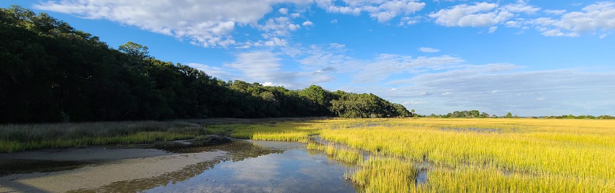
The peninsula itself is a made thing
Here is a fact that surprises almost everyone who lives here.
Roughly forty percent of the Charleston peninsula is not natural ground. It is made land. For three centuries, the low salt marshes at the edges of the city were filled in, first with ballast stones and trash and worse, later with earth and rubble hauled in by the load, until marsh became buildable lots. Colonial Lake. The hospital district. Much of Morrison Drive. Marsh, once. Made, now.
This is not trivia. It is the reason certain streets flood the instant the sky opens, because the ocean has a long memory and it knows exactly which blocks used to be creek. Only a few of the peninsula's old tidal creeks still run in the open. The rest are buried under the city, doing their best to come back up every time it rains.
Charleston is not just a city on the land. It is a city that remade the land to fit itself. That is either impressive or reckless depending on the forecast, and most days it is both.
Stand at the Four Corners of Law, or up on the High Battery, or out on any dock over the marsh at low tide, and you are standing on top of at least four different Charlestons at once: the one the Cusabo knew, the one the colonists planned, the one the enslaved built, and the one still filling in the marsh right now.
Charleston today: the newest chapter of a very old story
Now stand on that same peninsula and look around.
Charleston is one of the fastest-growing regions in the country, pulling in dozens of new residents a day and climbing toward a metro population well north of 850,000. Tourism runs into the billions of dollars in a single year, with millions of people coming to see the exact streets the Grand Modell drew in 1680. The median home price sits in the low four hundred thousands and keeps climbing, because it turns out a great many people want to wake up on this particular point of land.
None of that is new, when you think about it. People have wanted this ground since long before there were prices on it. The Cusabo built their lives here. The colonists moved an entire town to get the better view. We are simply the current people lucky enough to stand on it, and we will not be the last.
Why the land is worth celebrating
A country confident enough to look at all of its own ground, the beautiful and the brutal, is a country worth believing in. That is not a knock on the Fourth. It is the opposite.
The land beneath Charleston has been home, and hunting ground, and a walled fortress, and a slave market, and a battlefield, and a marsh someone decided to turn into a street. It has held people who were free and people who were not, people who arrived by choice and people who arrived in chains, people who guided the newcomers in and people who were pushed out. All of that happened on the same few square miles between two rivers.
We celebrate on the Fourth because a fragile fort made of local trees held off an empire. We reflect on the Fourth because the same ground carries every other story too. Both of those things can live on one piece of land. They already do.
So walk it this year. Look down before you look up at the fireworks. The ground you are standing on has been waiting a very long time, and it has more to say than any of us.
Happy Fourth of July from the Lowcountry. If this ground is pulling at you the way it has pulled at people for three hundred years, you know where to find me.
Marsh photograph: O. McCrosson, via Wikimedia Commons, licensed CC BY-SA 4.0. Historical details are drawn from public sources including Charles Towne Landing State Historic Site, the National Park Service at Fort Moultrie, and the Gullah Geechee Cultural Heritage Corridor. This post is for general educational and cultural interest only and does not constitute legal, financial, tax, or investment advice. Jennifer Dane is a licensed REALTOR® in South Carolina with eXp Realty LLC. Equal Housing Opportunity.